BMRCL has completed a feasibility study for a proposed 73-km elevated Namma Metro corridor from Kalena Agrahara to Kadugodi Tree Park. The project aims to connect Bengaluru’s major IT hubs, improve suburban connectivity, and reduce traffic congestion across rapidly growing areas.
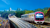
In a major step towards easing Bengaluru’s chronic traffic congestion and improving connectivity to its rapidly expanding suburbs, the Bangalore Metro Rail Corporation Limited (BMRCL) is planning a massive new metro corridor stretching from Kalena Agrahara in South Bengaluru to Kadugodi Tree Park in the eastern part of the city. A feasibility study for the proposed 73-km elevated metro line has now been completed, and sources said the report is expected to be submitted to the Karnataka government soon.
The ambitious project aims to strengthen public transport infrastructure across Bengaluru’s growing technology and residential corridors. If approved, the corridor is expected to significantly improve connectivity between key suburban regions and reduce dependence on road transport in some of the city’s most traffic-congested areas.
Feasibility Report Ready, DPR Decision Awaited
The feasibility report for the project was prepared by Introsoft Solutions Private Limited. Once submitted, the Karnataka government will review the report and decide whether to proceed with the next phase, which involves preparing a Detailed Project Report (DPR).
Related Articles

Officials said the DPR stage will include detailed technical studies, route planning, cost estimates, and land requirement assessments before the final approval process begins.
Metro Corridor To Connect Bengaluru’s South-East Tech Belt
The proposed metro corridor is planned to pass through several rapidly developing suburban regions, including Bannerghatta, Jigani, Attibele, Sarjapur, Dommasandra Circle, and Varthur Kodi.
The project is considered significant because it will directly connect Bengaluru’s southern and eastern technology corridors through a single metro line. The entire stretch is proposed as an elevated corridor and is expected to feature more than 50 metro stations.
Since many of these areas are still developing, officials estimate that the distance between stations may be longer compared to existing metro corridors within the city.
Direct Metro Connectivity Planned For International Cricket Stadium
One of the key highlights of the project is a proposed 5-km spur line that will provide direct metro connectivity to the upcoming international cricket stadium in Anekal taluk.
According to the plan, the spur line will branch out after the Jigani metro station and head towards the proposed stadium complex. Two additional stations are expected along this stretch. One station will be located adjacent to the stadium for direct access, while another will come up at Indlawadi village to serve nearby residential and commercial areas.
The proposed sports complex is planned on a massive scale and is expected to include an 80,000-seater cricket stadium, infrastructure for 24 sports disciplines, and a 30,000-seat auditorium.
Construction Could Begin Around 2029
After reviewing the feasibility report, the Karnataka government will take a call on commissioning the DPR. Officials estimate that preparing the DPR itself could take nearly a year.
If the project receives approvals from both the state and central governments without major delays, construction work could begin around 2029. Given the scale of the corridor, the project may take between five and ten years to complete.
Part Of BMRCL’s Larger Expansion Vision
The proposed 73-km corridor forms a key part of BMRCL’s larger metro expansion blueprint covering 210.9 km. Once all planned phases are completed, Bengaluru’s metro network is expected to expand to nearly 468 km.
The current focus of the expansion strategy is on improving connectivity within Bengaluru’s rapidly growing suburban regions rather than extending metro services to neighbouring cities such as Tumakuru, Bidadi, and Hosakote.
At the same time, BMRCL has shown limited interest in the proposed interstate metro connectivity to Hosur in Tamil Nadu. Instead, the agency is prioritising another proposal to extend the Yellow Line by 11 km from Bommasandra to Attibele.
Long-Term Solution To Bengaluru’s Traffic Woes
Urban transport experts believe the proposed corridor could play a crucial role in addressing Bengaluru’s worsening traffic congestion in the coming decades.
Designed around the city’s rapid urban expansion and growing IT corridors, the project is expected to transform connectivity across South and East Bengaluru while supporting future residential, commercial, and infrastructure growth.