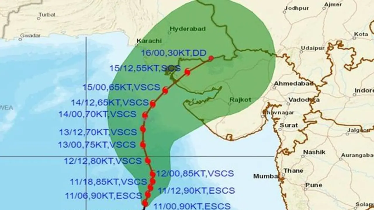
Cyclone Biparjoy: India Meteorological Department informs that Cyclone Biparjoy will make landfall around noon on June 15 between Gujarat's Mandvi and Pakistan's Karachi as a Very Severe Cyclonic Storm.
The very severe cyclonic storm Biparjoy (pronounced as 'Biporjoy') over the east-central Arabian Sea has moved north-northeastwards with a speed of 9 kmph during the past six hours and intensified into an Extremely Severe Cyclonic Storm.

At 0530 hours IST on June 11, Cyclone Biparjoy lay centred over the same region about 580 km west-southwest of Mumbai, 480 km south-southwest of Porbandar, 530 km south-southwest of Dwarka, 610 km south-southwest of Naliya and 780 km south of Karachi (Pakistan).
According to the India Meteorological Department, the cyclone will cross Saurashtra and Kutch and adjoining Pakistan coasts between Mandvi in Gujarat and Karachi in Pakistan around noon on June 15 as a Very Severe Cyclonic Storm.
How did Cyclone Biparjoy get its name?
The name 'Biparjoy' was assigned by Bangladesh and it signifies 'calamity' or 'disaster.' It was reportedly adopted by the World Meteorological Organization (WMO) and its member countries in 2020. This naming convention applies to all tropical cyclones that form over the North Indian Ocean, including the Bay of Bengal and the Arabian Sea. The choice of names for cyclones is determined based on regional rules.
The WMO and member countries of the United Nations Economic and Social Commission for Asia and the Pacific (ESCAP) collaborate in the naming of cyclones. According to the WMO, in the Atlantic and the Southern Hemisphere (Indian Ocean and South Pacific), tropical cyclones are named alphabetically, with alternating women's and men's names. However, the names in the Northern Indian Ocean are listed alphabetically by country and are gender-neutral.
What is a cyclonic storm?
According to the IMD classification, a system is classified as a cyclonic storm when its three-minute average maximum sustained wind speeds range from 63 to 88 kmph.
Similarly, wind speeds between 89 and 117 kmph indicate a severe cyclonic storm, while those ranging from 118 to 165 kmph indicate a very severe cyclonic storm. Wind speeds between 166 and 220 kmph are classified as an Extremely Severe Cyclonic Storm, and anything above 221 kmph is categorized as a super cyclone.
