Why Rain Clouds Have Vanished from Much of India This June? IMD Explains

Published : Jun 15, 2026, 04:09 PM IST

After a promising start, India’s southwest monsoon has entered a sudden lull. Rainfall activity has weakened sharply across several regions, raising concerns as large parts of the country wait for widespread seasonal showers

PREV
13
Rainfall Deficit Deepens Across Large Parts of India

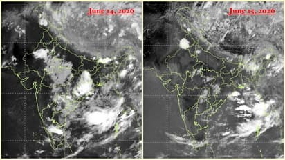
India is witnessing a significant drop in monsoon rainfall just days after the seasonal rains advanced across several states. According to meteorological data, the country received only 19.2 mm of rainfall between June 4 and June 15, compared to the normal average of 53.7 mm. This translates into a rainfall shortfall of nearly 64%.

ALSO READ: Kolkata Weather LATEST Update: Thunderstorms Likely in Nearby Districts, Rain May Bring Relief

The impact is visible across central, southern and eastern India, where rainfall has remained far below normal levels. Weather maps show widespread deficient and severely deficient rainfall conditions, indicating that the monsoon has failed to sustain its early momentum in many regions.

23
Satellite Images Reveal Unusually Weak Monsoon Activity

Recent satellite observations present a striking picture of the current weather situation. Areas that are usually covered by extensive monsoon cloud bands during June appear unusually clear.

Most of the active cloud formation is currently concentrated over the Himalayan region, northeastern India and areas north of the Indo-Gangetic plains. Meanwhile, the Arabian Sea branch of the monsoon appears fragmented and weak. This unusual cloud distribution suggests that although the monsoon has officially advanced geographically, it has not been able to generate widespread rainfall across much of the country.

33
Upper-Level Winds Are Disrupting Monsoon Circulation

Meteorologists attribute the slowdown to atmospheric conditions high above the Earth's surface rather than a lack of moisture over surrounding seas. A key factor is the westerly jet stream, which has shifted farther south than it normally does during the monsoon season.

This southward shift is interfering with the easterly jet stream, a crucial component that supports rising air currents and thunderstorm development over India. The stronger westerly winds are suppressing cloud growth and rainfall formation, even though moisture remains abundant over the Arabian Sea and the Bay of Bengal.

Experts describe the current situation as a temporary "monsoon pause" caused by upper-atmospheric dynamics. Forecast models indicate that rainfall activity may gradually recover later in the week as wind patterns begin to realign and monsoon circulation strengthens once again.

Stay updated with the Breaking News Today and Latest News from across India and around the world. Get real-time updates, in-depth analysis, and comprehensive coverage of India News, World News, Indian Defence News, Kerala News, and Karnataka News. From politics to current affairs, follow every major story as it unfolds. Get real-time updates from IMD on major cities weather forecasts, including Rain alerts, Cyclone warnings, and temperature trends. Download the Asianet News Official App from the Android Play Store and iPhone App Store for accurate and timely news updates anytime, anywhere.

Read more Photos on

Recommended Stories