United Nations Backs New World Map That Shows Africa’s True Size
Synopsis
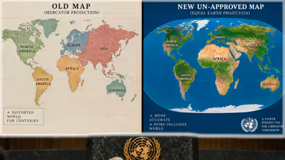
The United Nations has endorsed the 'Equal Earth' map projection to replace the traditional Mercator map, which distorts the relative size of continents. Championed by Togo and the African Union, the 'Correct the Map' initiative aims to provide a more accurate representation of Africa's true size.
*Dr. Krishna Kishore
The United Nations has endorsed a move to promote a new world map that more accurately represents the relative size of Africa and other continents.
The UN General Assembly approved a resolution encouraging the use of the “Equal Earth” projection instead of the traditional Mercator map, which has been widely used in schools, the media and digital platforms for centuries.
What is wrong with the old map?
The Mercator projection was developed in 1569 by Flemish cartographer Gerardus Mercator, primarily to help sailors navigate the seas. It proved highly useful because it accurately displayed directions. However, it significantly distorted the relative size of continents and countries.
Representing the Earth’s curved surface on a flat map inevitably creates some distortion. In the Mercator projection, regions closer to the poles—including North America, Europe, Russia and Greenland—appear much larger than they actually are. Meanwhile, areas closer to the Equator, such as Africa, Latin America and South Asia, appear comparatively smaller.
The contrast between Africa and Greenland is perhaps the clearest example. On the Mercator map, Greenland appears almost as large as Africa. In reality, Africa is approximately 14 times larger than Greenland.
The Equal Earth projection, developed in 2018, is designed to show the relative land areas of continents more accurately.
Africa leads the “Correct the Map” campaign
Togo introduced the “Correct the Map” resolution with the backing of the African Union. Its supporters argue that depicting Africa as smaller than it really is has influenced education, public perception and global political and economic attitudes toward the continent.
“A fair world begins with a fair map,” Togo’s Foreign Minister Robert Dussey said.
Togo has announced plans to introduce the new map in its school geography textbooks by the end of the year. It will also encourage other governments, educational institutions and technology companies to adopt more accurate map projections.
The United States was the only country to vote against it
The resolution received overwhelming support, with 164 countries voting in favour. The United States was the only country to oppose it.
Six countries—Serbia, Estonia, Georgia, Lithuania, Moldova and Ukraine—abstained. They did not publicly provide detailed individual explanations for their abstentions during the vote.
The United States argued that the resolution promoted an “ideological agenda” and diverted attention from more pressing issues involving international peace, prosperity and relations among nations. As the only country to cast a negative vote, the US position drew considerable attention.
India supports the map but reaffirms its borders
India voted in favour of the resolution, supporting its objective of representing the world’s regions more accurately and equitably.
However, India stressed that the adoption of a new map projection must not affect national sovereignty or international boundaries. It reiterated that the entire Union Territories of Jammu and Kashmir and Ladakh are integral and inalienable parts of India.
New Delhi made it clear that its support for the Equal Earth projection should not be interpreted as recognition of any territorial depiction inconsistent with India’s official position.
European Union supports the objective—with a clarification
The European Union and its member states supported the scientific, educational and public-awareness objectives of the resolution. The EU said a more accurate representation of Africa would improve geographical understanding and education.
However, the bloc emphasised that the measure was strictly about showing the relative size of landmasses. It does not affect national sovereignty, territorial status, disputed regions or internationally recognised borders.
The resolution should not be interpreted as endorsing any territorial claim or altering the legal status of any region, the EU said in its official explanation.
France welcomes the change
France strongly supported the initiative and announced that it would move away from the Mercator projection in favour of maps that represent actual land areas more faithfully.
French Foreign Minister Jean-Noël Barrot said that changing a map does not change the world, but correcting a distorted representation of it is an act of truth.
France’s position is also being viewed as part of its broader effort to strengthen relations with its former African colonies.
Will the new map change national borders?
No. The adoption of the Equal Earth projection does not change the territory, boundaries or sovereignty of any country. It only changes how the relative size of continents and countries is represented on paper or a screen.
The UN resolution is also not legally binding, and it does not ban the Mercator projection. Countries and institutions remain free to decide which map they use.
Because it accurately preserves direction, the Mercator projection may continue to be used in maritime and aviation navigation. Geographers, however, consider Equal Earth more suitable for education and for comparing the actual size of landmasses.
What happens next?
The new map is expected to appear gradually in school textbooks, atlases, government publications, newsrooms and digital mapping services. Governments, international organisations and technology companies will make their own decisions on whether and when to adopt it.
The UN decision does not change the geography of the planet. Instead, it seeks to change how people see and understand it. Most importantly, it restores to Africa the geographical scale and visual prominence that traditional world maps have denied it for centuries.