NISAR's New Radar Image Pierces Clouds Over Mississippi River Delta
Synopsis
A new image from the NASA-ISRO NISAR satellite penetrates cloud cover to reveal detailed views of the Mississippi River Delta. The radar-based image clearly maps the terrain, and the science team is preparing to release thousands of data files.
A newly released image from the NISAR mission has showcased the satellite's ability to penetrate cloud cover and reveal detailed features of Earth's surface, offering fresh insights into landscapes and ecosystems, while the science team has also made new sample datasets available.
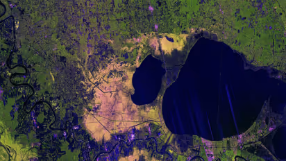
The colourful image, created using data gathered by the NASA-ISRO Synthetic Aperture Radar (NISAR) satellite in late autumn, focuses on the Mississippi River Delta region in southeastern Louisiana. It captures major landmarks including New Orleans and Baton Rouge, the Mississippi River, Lake Pontchartrain, and a diverse patchwork of wetlands, farmland, forests and residential areas. Unlike optical imagery taken the same day, which was largely obscured by clouds, the radar-based image clearly maps the terrain below. The release comes as the NISAR project prepares to provide thousands of mission data files for download in late February, with a smaller batch of sample files already issued to help researchers prepare for the larger dataset.
Radar Technology and Capabilities
While the satellite underwent post-launch system checks following its July liftoff, NASA's science team extracted early measurements from its L-band synthetic aperture radar to produce demonstration maps highlighting the instrument's capabilities. Developed by NASA's Jet Propulsion Laboratory in Southern California, the L-band radar uses microwaves with a wavelength of about 24 centimetres, allowing signals to pass through clouds and image the ground beneath.
Interpreting the Radar Image
Captured on November 29, the image demonstrates how the radar can distinguish between vegetation, trees and built environments -- a capability crucial for tracking forests and wetlands, as well as monitoring crops worldwide. Different colours in the image reflect varying land cover types and how they scatter radar signals. Sections of New Orleans appear green, while other parts show magenta tones depending on street orientation and building layout. The resolution is sharp enough to reveal the Lake Pontchartrain Causeway -- twin bridges stretching nearly 39 kilometres, recognised as the world's longest continuous bridge over water.
Beyond urban features, healthy forests west of the Mississippi River appear bright green, while areas of Maurepas Swamp display mixed yellow and magenta hues, indicating thinning tree populations. Agricultural plots on both sides of the river are also visible, with darker shades suggesting fallow fields and brighter colours pointing to taller vegetation such as crops.
Data Access and Applications
Data products generated from NISAR's L-band measurements will be available through the Alaska Satellite Facility Distributed Active Archive Center in Fairbanks, which stores and distributes NASA's SAR data. Officials said insights from NISAR are expected to support disaster response, infrastructure monitoring and agricultural management.
About the NISAR Mission
NISAR is a joint mission between NASA and the Indian Space Research Organisation (ISRO) and was launched on July 30 from Satish Dhawan Space Centre on India's southeastern coast. Managed by Caltech, JPL leads the US contribution and supplies the L-band SAR and antenna reflector, while ISRO provides the spacecraft bus and S-band SAR.
The satellite is the first to carry two SAR instruments operating at different wavelengths and will observe Earth's land and ice surfaces twice every 12 days. It gathers data using a large drum-shaped reflector measuring 12 metres wide -- the largest radar antenna reflector NASA has ever sent into space. (ANI)
Check the Breaking News Today and Latest News from across India and around the world. Stay updated with the latest World News and global developments from politics to economy and current affairs. Get in-depth coverage of China News, Europe News, Pakistan News, and South Asia News, along with top headlines from the UK and US. Follow expert analysis, international trends, and breaking updates from around the globe. Download the Asianet News Official App from the Android Play Store and iPhone App Store for accurate and timely news updates anytime, anywhere.