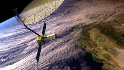
NISAR: World’s most expensive satellite jointly developed by India, US likely to be launched in March 2025

Synopsis
The NISAR satellite, a collaborative project between India and the US, is set to be launched in March 2025 after delays. The satellite, designed to monitor Earth's surface with unparalleled precision, uses dual-frequency radar systems from NASA and ISRO.
After several delays, NASA has confirmed that NISAR, the world's most advanced and costly Earth observation satellite, developed jointly by India and the US over the past decade, is now expected to launch in March next year. The satellite was previously planned for a 2024 launch.
Antenna modifications, orbital constraints set back Indo-US NISAR launch to 2025
In a statement, the US space agency said, “Nasa and ISRO are looking at a likely launch date in March 2025. Short for Nasa-Isro Synthetic Aperture Radar, NISAR will scan nearly all of Earth’s land and ice surfaces twice every 12 days to measure changes in the planet’s ecosystems, its land and sea ice, and its solid Earth. The NISAR satellite will launch from Satish Dhawan Space Centre on India’s southeastern coast.”
The 2.8-tonne NISAR satellite, which began development following an agreement between India and the US in 2014, is designed to monitor planetary changes with exceptional precision. With an estimated cost of over Rs 5,800 crore, this satellite is the first of its kind globally, featuring dual-frequency radar: NASA's L-band (1.25 GHz) and ISRO's S-band (3.20 GHz), ensuring unmatched data accuracy.
In October 2024, its key components were shipped from the US to India, marking a major logistical achievement. However, the mission experienced delays due to technical issues with its 12-meter radar antenna reflector.
The data from NISAR will aid global efforts in managing natural resources and hazards more effectively, while also providing valuable insights for scientists to comprehend the impacts and speed of climate change. Additionally, it will enhance the understanding of Earth's crust, its rigid outer layer.
NASA stated that the observations from NISAR will aid global researchers in gaining a deeper understanding of changes in Earth's surface, including its ice sheets, glaciers, and sea ice. The mission will also monitor alterations in forest and wetland ecosystems, as well as the movement and deformation of the Earth's crust, such as earthquakes, landslides, and volcanic activity.
The global and rapid coverage from NISAR will provide unprecedented opportunities for disaster response, producing data to assist in mitigating and assessing damage, with observations before and after disasters in short time frames. Its data will also help scientists understand solid Earth movements and their implications, it said.
The satellite's primary features include the ability to produce high-resolution images using radio signals, operate efficiently in dark conditions and adverse weather, detect surface changes as small as one inch, and penetrate thick vegetation for detailed mapping.
Check the Breaking News Today and Latest News from across India and around the world. Stay updated with the latest World News and global developments from politics to economy and current affairs. Get in-depth coverage of China News, Europe News, Pakistan News, and South Asia News, along with top headlines from the UK and US. Follow expert analysis, international trends, and breaking updates from around the globe. Download the Asianet News Official App from the Android Play Store and iPhone App Store for accurate and timely news updates anytime, anywhere.