Hurricane Helene intensifies; Stunning satellite image reveals storm's massive scale
Synopsis
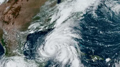
A stunning satellite image from NOAA's GOES-16 (GOES East) captures the formidable scale and intensity of Hurricane Helene as it moves through the Gulf of Mexico toward Florida's coast. The image highlights the storm's expansive reach and clearly defined eye, illustrating the serious threat it poses to the region.
Hurricane Helene is gaining strength as it approaches the U.S. Gulf Coast. The Category 1 storm is expected to rapidly strengthen into a powerful Category 4 hurricane before making landfall in Florida on Thursday evening. Forecasters are warning of "life-threatening" storm surges, destructive winds, and widespread flooding across much of Florida and the southeastern U.S.
The U.S.-based National Hurricane Center (NHC) reported that Hurricane Helene is anticipated to continue its northward path through the Gulf of Mexico before hitting Florida on Thursday evening local time. In preparation for the storm's landfall, the governors of Florida, Georgia, North Carolina, South Carolina, and Virginia have declared states of emergency.
A dramatic image from NOAA's GOES-16 satellite showcases Hurricane Helene's enormous size and strength as it approaches Florida's coast. The snapshot reveals the storm's expansive reach and distinct eye, signaling a potent threat.
After rapidly intensifying into a hurricane on Wednesday, Helene has escalated to a Category 4 storm, packing maximum sustained winds of 130 mph.
Hurricane Helene's impact will be felt far inland even before making landfall. Heavy rainfall is forecast to begin in portions of the southeastern United States, gradually moving northward into the southern Appalachians through Friday. Some areas are expected to receive up to 18 inches of rain, raising concerns about widespread flooding and potential landslides in mountainous regions.
As Hurricane Helene bears down on the coast, residents in its path are advised to finalize preparations immediately and follow evacuation orders without delay. This powerful storm serves as a stark reminder of the growing intensity of Atlantic hurricanes, with research suggesting climate change contributes to their rapid intensification.
Check the Breaking News Today and Latest News from across India and around the world. Stay updated with the latest World News and global developments from politics to economy and current affairs. Get in-depth coverage of China News, Europe News, Pakistan News, and South Asia News, along with top headlines from the UK and US. Follow expert analysis, international trends, and breaking updates from around the globe. Download the Asianet News Official App from the Android Play Store and iPhone App Store for accurate and timely news updates anytime, anywhere.