Bengaluru: Proposed Roads Raise Concerns Over Lakes and Environmental Impact
Synopsis
Bengaluru’s proposed road network has raised environmental concerns over lake buffer zones, stormwater drains and flooding risks. Experts and environmental observers have called for route reviews, environmental assessments and better public transport planning.
The Greater Bengaluru Authority (GBA) and the Bengaluru Development Authority (BDA) have proposed an extensive road network spanning hundreds of kilometres to address traffic congestion and improve the city’s infrastructure. While the plan may appear to offer relief to commuters struggling with daily traffic jams, the proposed road alignments have raised serious environmental concerns. According to the project’s traffic network maps, several routes reportedly pass through lake buffer zones, stormwater drains and ecologically sensitive areas. This has prompted questions about their potential impact on Bengaluru’s lakes, natural drainage systems and long-term environmental sustainability.
Proposed Roads Raise Concerns Over Lake Buffer Zones and Water Bodies
The proposed road alignments have drawn attention to their potential impact on several lakes and stormwater drains across Bengaluru.
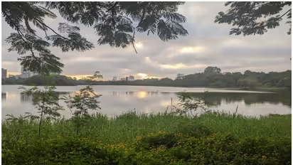
The plan reportedly includes roads along the shores and buffer zones of Doddanekundi, Nallurahalli, Begur, Puttenahalli and Doddabommasandra lakes. It also proposes roads around other major water bodies, including Bellandur, Basapura and Garvebhavipalya lakes.
Environmental concerns centre on the possibility that construction in these areas could reduce the natural water-holding capacity of lakes, obstruct rainwater flow and increase the risk of urban flooding. Such development could also put pressure on ecologically sensitive areas and potentially encourage commercial real estate development in previously undisturbed zones.
Do the Proposed Road Alignments Comply With NGT Rules?
Government agencies are expected to protect the city’s lakes, wetlands and other ecologically sensitive areas. However, concerns have also been raised about the presence of existing infrastructure within lake beds and buffer zones under the GBA’s jurisdiction.
According to concerns highlighted by environmental observers, 39 lakes within the GBA limits have been affected by encroachments involving public infrastructure. Playgrounds, public parks and sewage treatment plants are among the facilities reportedly located within lake beds.
The National Green Tribunal (NGT) has issued directions concerning the protection of lakes and their buffer zones. The proposed road alignments have therefore raised questions about whether the projects would comply with applicable environmental regulations and judicial directions.
A detailed assessment of the proposed routes and relevant legal provisions would be necessary to determine whether any specific alignment violates existing restrictions.
Public Transport, Not Wider Roads, Is the Long-Term Solution
Although new roads may offer some relief at specific congestion points, expanding road capacity alone may not provide a lasting solution to Bengaluru’s traffic problems. Additional road capacity can encourage greater use of private vehicles, potentially leading to renewed congestion over time.
The city’s Comprehensive Mobility Plan (CMP), prepared in 2020, emphasised sustainable transport and the importance of public transport. However, concerns remain about the pace of implementation of the measures outlined in the plan.
Bengaluru needs a reliable and expanded fleet of Bengaluru Metropolitan Transport Corporation (BMTC) buses, faster progress on Namma Metro and suburban rail projects, and safer infrastructure for pedestrians and cyclists. Strengthening these alternatives could help reduce dependence on private vehicles and improve urban mobility.
Need for Coordinated Transport Planning
Several agencies, including the GBA, BDA, Bengaluru Metropolitan Land Transport Authority (BMLTA) and Directorate of Urban Land Transport (DULT), play important roles in the city’s urban development and transport planning.
Better coordination among these institutions is essential to ensure that road projects align with Bengaluru’s broader mobility objectives and environmental priorities.
The BMLTA has an important role in promoting integrated transport planning. Proposed road projects should be assessed against the objectives of the CMP, with due consideration given to public transport, pedestrian access, cycling infrastructure and environmental protection.
What Should Happen Next?
The proposed road network has raised questions about how Bengaluru can address traffic congestion without compromising its lakes and natural drainage systems.
The following measures warrant consideration:
Independent Environmental Assessment: Authorities should commission an independent environmental and hydrological assessment of the proposed road alignments to evaluate their potential impact on lakes, stormwater drains and flood risks.
Review of Sensitive Routes: Road alignments that could damage lakes, drainage channels or buffer zones should be reconsidered in accordance with applicable environmental regulations and court or tribunal directions.
Public Disclosure: The authorities should publish detailed route maps and explain how the proposed roads would connect with the existing network and support public transport.
Priority for Sustainable Mobility: Greater emphasis should be placed on BMTC services, Metro expansion, suburban rail, pedestrian facilities and cycling infrastructure.
Bengaluru’s traffic congestion requires long-term planning, but infrastructure expansion should not come at the expense of the city’s natural resources. A transparent review of the proposed routes, supported by environmental assessments and coordinated transport planning, would help the authorities balance mobility needs with the protection of lakes and ecologically sensitive areas.
Stay updated with the Breaking News Today and Latest News from across India and around the world. Get real-time updates, in-depth analysis, and comprehensive coverage of India News, World News, Indian Defence News, Kerala News, and Karnataka News. From politics to current affairs, follow every major story as it unfolds. Download the Asianet News Official App from the Android Play Store and iPhone App Store for accurate and timely news updates anytime, anywhere.