Monster Cloud Alert: 3,000 km Giant Looms Over India, Which States Are at Risk?
Synopsis
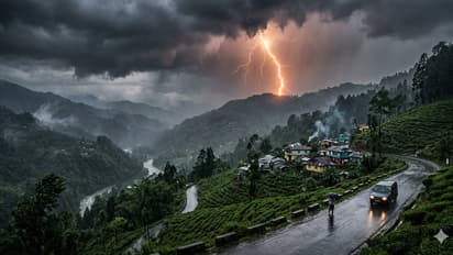
Just imagine a single cloud stretching from Kashmir to Kanyakumari. This isn't science fiction. A 3,000 km long and 500 km wide 'monster cloud' system, called a Mesoscale Convective System (MCS), has formed over the Bay of Bengal. It's now hurtling towards land at 100 km per hour.
If you see the sun disappear during the day and hear a constant rumbling sound, be warned. This isn't your usual summer storm or Kalbaisakhi. This is an 'MCS' – a Mesoscale Convective System.
The weather department says a giant is waking up in the Bay of Bengal. It's a single cloud system, 3,000 km long. To give you an idea, that's the distance from Delhi to Chennai. This massive formation is called a 'squall line', and it's almost the size of our entire country.
1. What is this monster cloud and how does it form?
A normal thundercloud is about 10-20 km wide. But when the Bay of Bengal's water heats up to 31 degrees Celsius and strong westerly winds blow in from the Arabian Sea, hundreds of these thunderclouds merge. That's how an MCS is born.
Think of it as a 'cloud factory'. In its centre is a 15-18 km high 'hot tower' that sucks up 10 tonnes of water every second. Then, it dumps it all down like a bomb. We're talking about 200-300 mm of rain in one night. To put that in perspective, that's Kolkata's entire rainfall for a month, but delivered in just six hours.
2. What kind of disasters can it cause?
This system has five terrifying forms:
Cloudbursts: In hilly areas, this can lead to a cloudburst, with 100 mm of rain in just one hour. The 2013 Kedarnath tragedy, where 6,000 people died, was caused by this. This time, Sikkim, North Bengal, and Meghalaya are the targets.
Lightning Tsunami: An MCS can produce 20,000 to 30,000 lightning strikes per hour. In 2022, 83 people died in Bihar in a single day from lightning strikes. This year could break records. Odisha, Jharkhand, and West Bengal are at high risk.
Flash Floods: Cities like Kolkata, Howrah, Dhaka, and Chittagong have drainage systems that can handle about 50 mm of rain. If 200 mm falls, the streets will turn into rivers. Metro services and airports could shut down.
Super Nor'westers: At the front of the cloud is a 'gust front' with winds of 120-150 km/h. It can blow away tin roofs, trees, and electric poles, just like Cyclone Amphan did.
Crop Destruction: Paddy, jute, and vegetables will rot in the fields. In coastal areas, saltwater will flood the land, making it unusable for farming for the next three years.
ALSO READ: India Monsoon Alert: IMD Warns of Weak Monsoon as Super El Nino Builds in Pacific; Check Forecast
3. Why is it so dangerous this time?
There are three main reasons:
1. A Hotter Sea: The Bay of Bengal is 1.5 degrees warmer than usual, thanks to the El Niño effect. Warmer water means more moisture in the air, which fuels these monster clouds.
2. Madden-Julian Oscillation: A 30-60 day weather pattern is currently active over India. It's basically providing extra 'food' for the MCS to grow stronger.
3. Western Disturbance: Cold winds from the west are clashing with the hot, moist air from the bay. It's like throwing a lit match on gunpowder.
4. Which states are on alert?
According to the IMD's latest map:
Red Alert: Odisha coast, Gangetic West Bengal, and Bangladesh. These areas could see over 200 mm of rain between May 18-21, with a 'severe' risk of lightning.
Orange Alert: Jharkhand, Bihar, Sikkim, Assam, and Meghalaya. Expect 100-150 mm of rain and 80 km/h winds.
Yellow Watch: Andhra Pradesh, Chhattisgarh, and eastern Uttar Pradesh will see scattered heavy showers.
For Kolkata, the worst period is expected from the night of May 19 to the morning of May 20. Authorities have advised that offices and schools should remain closed.
ALSO READ: Himachal to see dry spell, soaring temps after brief rain: IMD
5. How can you stay safe?
Here are five must-do things:
1. During lightning: Get inside a proper 'pucca' building. Stay away from trees, towers, and water bodies. Do not charge your mobile phone.
2. In a flash flood: Do not walk through knee-deep water. Manholes could be open, and there could be live electrical wires in the water.
3. During the storm: Stay away from windows, as breaking glass can be deadly. Stock up on emergency lights, dry food, and water.
4. A message for farmers: If you have ripe paddy, try to harvest it by May 18. Clear the drainage channels in your fields to let water flow out.
5. Use technology: Track lightning in real-time using apps like Mausam, Damini, and Umang. They can give you a 30-minute warning.
A final word:
Remember the 2013 Kedarnath disaster, the 2015 Chennai floods, and the 2022 Sylhet floods? An MCS was the villain in all of them. This time, the monster is even bigger, with a 3,000 km reach.
When nature is angry, even science can feel helpless. So, please stay alert. Don't spread rumours and follow the IMD bulletins. You can always rebuild property, but you can't get a life back. Once this cloud passes, the sun will shine again. But until then, your home is the safest place to be.
Stay updated with the Breaking News Today and Latest News from across India and around the world. Get real-time updates, in-depth analysis, and comprehensive coverage of India News, World News, Indian Defence News, Kerala News, and Karnataka News. From politics to current affairs, follow every major story as it unfolds. Get real-time updates from IMD on major cities weather forecasts, including Rain alerts, Cyclone warnings, and temperature trends. Download the Asianet News Official App from the Android Play Store and iPhone App Store for accurate and timely news updates anytime, anywhere.