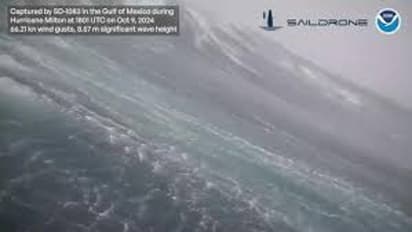
Strong winds & giant waves! Drone captures monstrous 28-foot wave inside Hurricane Milton (WATCH)

Synopsis
A stomach-churning video captured by a NOAA drone revealed the swirling, life-threatening waves of Hurricane Milton as the storm roiled through the Gulf of Mexico ahead of landfall.
A stomach-churning video revealed the swirling, life-threatening waves of Hurricane Milton as the storm roiled through the Gulf of Mexico ahead of landfall. A sailing drone from the National Oceanic and Atmospheric Administration (NOAA) measured the 28-foot wave with strong wind gusts of 75.98 miles per hour, located approximately 40 nautical miles from the center of Milton.
"Inside Hurricane Milton, @saildrone reported wave height of 28.12 feet and wind gusts as strong as 75.95 mph while 40 nautical miles from the center of the storm. This research represents a collaborative endeavor to better understand the role of the ocean in hurricanes," the agency captioned the video on X (formerly Twitter).
Hurricane Milton struck Florida on Wednesday as a Category 3 storm, unleashing powerful winds exceeding 100 mph (160 kph), heavy rainfall, and spawning several tornadoes across the state. Although Tampa avoided a direct hit, the storm continued to bring a potentially deadly storm surge to the city and other densely populated areas along Florida’s Gulf Coast, including St. Petersburg, Sarasota, and Fort Myers.
As Hurricane Milton moved across the Florida Peninsula, heavy rains were expected to cause flooding in inland areas along rivers and lakes before the storm eventually emerged in the Atlantic Ocean on Thursday.
Milton made landfall as an extremely dangerous Category 3 storm around 8.30 pm Wednesday near Siesta Key, Florida, with maximum sustained winds of 120 miles per hour, according to the NOAA’s National Hurricane Center.
By Wednesday night, over 1.5 million homes and businesses in Florida were without power, as reported by poweroutage.us, which monitors utility reports. The most significant outages were recorded in Hardee County, along with neighboring Sarasota and Manatee counties.
Even before Milton made landfall, tornadoes were already touching down throughout the state. The Spanish Lakes Country Club near Fort Pierce, located on Florida’s Atlantic Coast, suffered significant damage, with homes destroyed and several residents losing their lives.
Milton is just the latest system in what scientists are calling one of the weirdest storm seasons they’ve ever witnessed. In just 46.5 hours, Milton intensified from a 40 mph tropical storm to a top-of-the-charts Category 5 hurricane before dropping to Category 3 status.
Check the Breaking News Today and Latest News from across India and around the world. Stay updated with the latest World News and global developments from politics to economy and current affairs. Get in-depth coverage of China News, Europe News, Pakistan News, and South Asia News, along with top headlines from the UK and US. Follow expert analysis, international trends, and breaking updates from around the globe. Download the Asianet News Official App from the Android Play Store and iPhone App Store for accurate and timely news updates anytime, anywhere.