Sriharikota’s Midnight Roar: India’s Native GPS Takes Flight
Synopsis
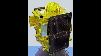
ISRO successfully launched the NVS-03 satellite aboard the GSLV-F18 rocket, marking a crucial step in reviving India's indigenous NavIC navigation system. Equipped with an Indian-made atomic clock, this satellite will enhance civilian services like mobile mapping and secure independent navigation for the armed forces.
Imagine opening a map on your phone and finding the little blue dot guided not by a foreign satellite thousands of kilometres away, but by one built and launched by Indian hands. That future moved closer on Friday night, when the GSLV-F18 rocket lifted off from the Second Launch Pad at Sriharikota's Satish Dhawan Space Centre at 11:51 pm. Just over twenty minutes later, NVS-03 was released into its planned Geosynchronous Transfer Orbit. Think of it as a waiting room in space, a temporary path from which the satellite will gradually climb to its permanent home.
For ISRO Chairman Dr V. Narayanan, the moment carried visible relief. He declared the mission a success and thanked the engineers and companies whose labour had gone into the 2,232 kg satellite. That relief was earned the hard way. On January 29, 2025, its predecessor NVS-02 never reached its intended orbit. A tiny pyro valve, the device that controls fuel flow to the engine, failed to open because the electrical signal meant to trigger it was lost. One small part, one lost signal, and an entire satellite was stranded.
Why should this matter to someone who simply wants to find the nearest bus stop or dodge traffic? Because NavIC, short for Navigation with Indian Constellation, is India's own answer to America's GPS. Earlier known as the Indian Regional Navigation Satellite System, it does not try to cover the globe. It concentrates on India and a belt stretching 1,500 km beyond the borders, which is precisely where most of us live, travel, fish, farm and work.
The uses are closer to home than they sound. NavIC can track trains, vehicles and ships in real time, guide fishermen at sea, help farmers in their fields, and point rescue teams to the right spot after floods or earthquakes. Less visibly, it broadcasts extremely precise time signals. Banks settling payments, mobile towers passing your call from one cell to the next, and the grid keeping electricity flowing all depend on clocks that agree to the microsecond. Satellite time is that silent referee.
This is where NVS-03's most delicate cargo comes in. It carries an atomic clock developed in India using rubidium, a soft silvery metal whose atoms tick with astonishing regularity, alongside other atomic clocks purchased from abroad. Navigation works by timing how long a radio signal takes to travel from satellite to receiver; even a billionth of a second of error becomes metres on the ground. A clock made at home means the system's heartbeat is no longer imported.
The satellite will speak to receivers on three radio channels, named L1, L5 and S. Each is simply a different frequency, like three stations on the same radio dial: L5 and S serve professional users such as aviation, shipping and specialised equipment, while L1 is the channel most ordinary phones already use. That is why L1 deserves special attention. First added to NavIC with NVS-01, it lets manufacturers bring the service to many more handsets, building on the phones that already support NavIC today. Dr Narayanan, however, asked for patience. Full use on mobile phones must wait until the remaining satellites are launched and the complete network is in place.
Beyond convenience lies a harder truth about security. NavIC was designed as a family of seven satellites. Three sit in geostationary orbit, which means they hover over the same patch of Earth at all times, much like a lamp fixed to a ceiling. The other four follow tilted orbits that make them drift slowly north and south in a regular pattern, sweeping across the sky to fill in the gaps. NVS-03 belongs to the first group and will take its permanent place at 32.5° East longitude, roughly above the Indian Ocean, from where it will watch over the subcontinent without moving. As older satellites aged and replacement launches such as NVS-02 stumbled, only three working satellites remained. Since at least four are needed to fix a position independently, India's armed forces could not use their own system to guide missiles, coordinate warships, navigate soldiers or direct fighter aircraft. They have had to lean on America's GPS and Russia's GLONASS.
That dependence carries a painful memory. During the 1999 Kargil War, India was denied certain GPS information at a critical hour. A foreign operator can degrade accuracy or switch off access during conflict. Modern ballistic missiles and precision-guided weapons live or die on Position, Navigation and Timing signals; owning those signals is a matter of sovereignty.
Once operational, NVS-03 becomes the fourth working satellite, bringing NavIC back to life for soldier and citizen alike. Space Minister Jitendra Singh, posting on X, congratulated Team ISRO, credited the reforms introduced under Prime Minister Narendra Modi, and invoked the dreams of Vikram Sarabhai and Satish Dhawan. Those dreams now orbit quietly overhead.
(Girish Linganna is an award-winning science communicator and a Defence, Aerospace & Geopolitical Analyst. He is the Managing Director of ADD Engineering Components India Pvt. Ltd., a subsidiary of ADD Engineering GmbH, Germany.)
Stay updated with the Breaking News Today and Latest News from across India and around the world. Get real-time updates, in-depth analysis, and comprehensive coverage of India News, World News, Indian Defence News, Kerala News, and Karnataka News. From politics to current affairs, follow every major story as it unfolds. IMD cities weather forecastsRain Cyclone Asianet News Official App